
ALROSA’s Severalmaz Pioneers Advanced Drone Technology for Mine Surveying, Ushering in a New Era of Digital Mining
The global mining industry is undergoing a profound transformation, driven by technological advancements aimed at enhancing efficiency, safety, and sustainability. Leading this charge is ALROSA Group, one of the world’s largest diamond mining companies, through its subsidiary PJSC Severalmaz. In a significant move towards future-proofing its operations, Severalmaz recently conducted a groundbreaking pilot project, successfully testing unmanned aerial vehicles (UAVs), commonly known as drones, for critical mine surveying tasks at its Lomonosov Mining and Processing Division. This initiative marks a pivotal step in integrating advanced digital solutions into core mining operations, promising a paradigm shift from traditional methods to a more dynamic, precise, and secure approach.
Revolutionizing Mine Surveying with Cutting-Edge Drone Technology
Mine surveying is the cornerstone of any successful mining operation, providing crucial data for planning, progress monitoring, and resource management. Traditionally, this process has been labor-intensive, time-consuming, and often fraught with safety risks. However, ALROSA’s Severalmaz is embracing innovation to overcome these challenges. The pilot test at the Lomonosov Mining and Processing Division showcased the impressive capabilities of specialized industrial drones in conducting comprehensive surveys of vast land objects.
The drones deployed in this pioneering test were the Geoscan 401 Geodesy quadcopter and the Geoscan 101 Geodesy aircraft, both renowned for their precision and reliability in professional geodetic applications. These state-of-the-art UAVs are specifically engineered for complex surveying tasks, requiring no special modifications for their use in the demanding mining environment. Their robust design and advanced sensor technology make them ideal tools for capturing highly accurate spatial data across diverse terrains and structures typical of mining sites.
Unprecedented Scope and Efficiency in Data Collection
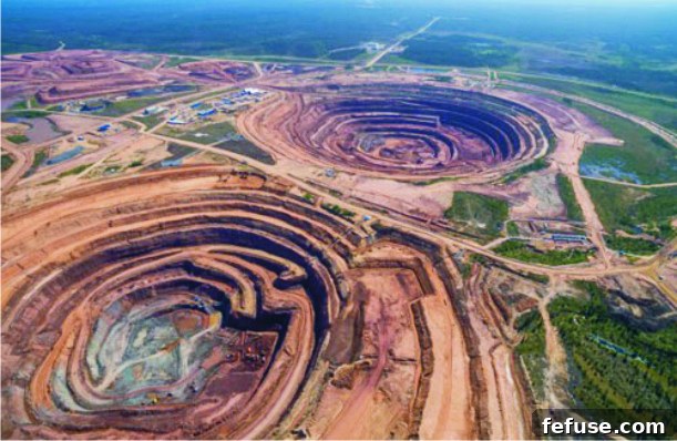
During the tests, the drones systematically surveyed a wide array of critical mining infrastructure and geological features. This included the expansive open-pit mine, towering waste dumps, vital ore storage facilities, and other bulked land objects spread across a substantial area exceeding 3 square kilometers. The operational efficiency demonstrated by these unmanned systems was remarkable. Despite a total flight time of just 2 hours and 40 minutes, the drones covered an impressive cumulative distance of approximately 100 kilometers, gathering an immense volume of data with unparalleled speed and detail.
This rapid data acquisition capability stands in stark contrast to conventional surveying methods, which often necessitate weeks or even months of painstaking fieldwork. The ability of drones to quickly traverse large, complex, and potentially hazardous areas allows mining companies to obtain up-to-date topographical information far more frequently. This continuous stream of fresh data empowers engineers and planners to make more informed, real-time decisions, thereby optimizing operational workflows and resource allocation.
Transformative Benefits: Accuracy, Speed, and Enhanced Safety
The preliminary findings from Severalmaz’s drone trials unequivocally underscore the profound advantages of integrating this technology into mining practices. ALROSA’s official statements confirm that “preliminary estimates show that the use of unmanned technologies provides high survey accuracy, increases the speed and safety of work.” These three pillars—accuracy, speed, and safety—are paramount in the mining sector, and drones are proving to be game-changers in each aspect.
Precision Data for Informed Decision-Making
The core of effective mining lies in precise measurements and accurate geological modeling. The company elaborated that the measurement error observed during the drone surveys was “within acceptable limits with a large margin.” This exceptional level of precision is crucial for various mining applications, from calculating the volume of excavated rock mass to ensuring compliance with mine plans and environmental regulations. High-fidelity data derived from drone surveys translates into better resource management, reduced waste, and more accurate financial forecasting.
Dramatic Reduction in Surveying Time
One of the most immediate and tangible benefits highlighted by Severalmaz is the significant acceleration of surveying tasks. The use of drones made the survey much faster compared to traditional methods, such as laser scanning. For instance, in one specific task, the duration of work was dramatically reduced from 115 minutes to a mere 65 minutes. Such time savings, when scaled across an entire mining operation, can lead to substantial gains in productivity and efficiency. Less time spent on surveying means more operational uptime for excavation, processing, and other core activities, directly impacting the bottom line.
Elevating Safety Standards in Hazardous Environments
Perhaps the most critical advantage of drone-based surveying, particularly in the inherently dangerous environment of a mine, is the significant improvement in safety. Traditional surveying often requires personnel to access steep slopes, unstable terrain, or areas with heavy machinery in operation, exposing them to considerable risks. By deploying drones, mining companies can eliminate or drastically reduce human exposure to these hazardous conditions. This allows for safe data collection from areas previously deemed too dangerous or inaccessible, thereby protecting valuable human capital and minimizing the potential for accidents. The reduction in work duration from 115 to 65 minutes also inherently improves safety by minimizing the time workers spend in potentially risky areas, even if they are involved in other aspects of the surveying process.
Pioneering Digital Transformation: The Concept of Digital Production
This initiative by Severalmaz and ALROSA is more than just an operational upgrade; it represents a strategic leap towards building the “concept of digital production at a mining enterprise.” Alexey Tikhonov, Project Director of ALROSA’s Strategic Projects and Analytics Center, emphasized this vision, stating, “The use of drones for surveying is one of the components for building the concept of digital production at a mining enterprise.” This concept envisions a fully integrated, data-driven operational model where information flows seamlessly across all aspects of mining.
The rich, high-resolution data captured by drones forms the foundation for creating sophisticated digital models of the mining site. As Tikhonov further noted, “The resulting polygonal digital model of the open-pit mine can be used to automate the processes of calculating the volume of excavated rock mass, comparing the current state of mining operations with the mining project, planning of mining operations, and to solve some other tasks.”
Applications of Digital Models in Mining
The creation of a dynamic digital twin of the mine, powered by drone data, unlocks a myriad of advanced applications:
- Automated Volume Calculation: Precisely calculating the volume of extracted material and waste dumps becomes instantaneous and highly accurate, aiding in inventory management and production reconciliation.
- Progress Monitoring and Project Comparison: The digital model allows for real-time comparison of the current mine state against original design plans, identifying deviations and enabling prompt corrective actions.
- Optimized Operational Planning: Engineers can simulate different mining scenarios, plan blast patterns, design haul roads, and optimize equipment deployment within the digital environment, leading to more efficient and cost-effective operations.
- Environmental Monitoring: Drones can continuously monitor environmental parameters, such as water runoff, dust dispersion, and rehabilitation progress, ensuring compliance and promoting sustainable mining practices.
- Infrastructure Inspection: Beyond surveying, drones can be utilized for inspecting critical infrastructure like conveyor belts, pipelines, and highwalls, identifying potential issues before they escalate.
- Geotechnical Analysis: Detailed topographical data supports advanced geotechnical analysis, helping to predict and mitigate risks associated with slope stability and ground movement.
This integration of drone technology into the digital framework of a mining operation transforms raw data into actionable intelligence, driving continuous improvement and fostering a proactive management approach.
A Promising Future for Russian Mining
The adoption of drone-based surveying technology is a relatively nascent field within the Russian mining industry. Igor Ivanov, Chief Engineer of PJSC Severalmaz, acknowledged this pioneering role: “Right now, mining companies in our country are only testing the drone-based surveying technology. For Severalmaz, as well as for ALROSA as a whole, this is also the first experience of their use.” This initial foray, however, has yielded extremely positive results.
Ivanov expressed optimism for the future, adding, “We still need to do an in-depth analysis of the results, but preliminary estimates show that the use of drones for mine and geodetic surveying can be very promising.” This sentiment resonates across the global mining landscape, where drones are increasingly recognized as indispensable tools for modern operations. The successful implementation by Severalmaz positions ALROSA as a frontrunner in embracing digital innovation within the sector, potentially setting new benchmarks for efficiency and safety across Russia’s vast mining complex.
As the industry continues to evolve, the demand for precise, timely, and safe data acquisition will only grow. ALROSA’s strategic investment in drone technology through Severalmaz is a clear indication of its commitment to leveraging cutting-edge solutions to maintain its competitive edge, optimize resource utilization, and ensure the highest standards of operational excellence. This pilot project is not merely a test; it is a blueprint for the future of intelligent and sustainable mining.
Pic Cap: Aerial shot of Severalmaz
Pic Courtesy: PJSC ALROSA