
Revolutionizing Mining: Geoscan Drones Transform Surveying for Severalmaz and ALROSA
The global mining industry stands at the precipice of a significant technological transformation, driven by innovations in automation, data analytics, and remote sensing. At the forefront of this evolution, unmanned aerial vehicles (UAVs), commonly known as drones, are proving to be game-changers in operational efficiency, safety, and data precision. A recent landmark trial conducted by PJSC Severalmaz, a key subsidiary of the ALROSA Group and a major diamond producer, exemplifies this shift. Collaborating with Geoscan, a leading developer of aerial mapping solutions, Severalmaz successfully implemented advanced drone technology for comprehensive mine and geodetic surveying at its Lomonosov Mining and Processing Division, heralding a new era for digital production in the sector.
The Imperative for Innovation in Mine Surveying
Traditional mine surveying methods, while accurate, often present a myriad of challenges. These include time-consuming procedures, potential safety risks for personnel operating in hazardous terrains, and the laborious nature of data acquisition over vast and complex landscapes. With the increasing demand for operational efficiency and the push towards sustainable mining practices, the industry has actively sought innovative solutions. Drone technology emerges as a compelling answer, offering the ability to rapidly capture high-resolution imagery and precise geospatial data, fundamentally altering how mining operations monitor, plan, and execute their activities. The adoption of such cutting-edge tools is not merely an upgrade but a strategic move towards building more resilient, efficient, and safer mining ecosystems.
A Strategic Partnership: Severalmaz Pioneers Drone-Based Surveying
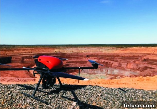
The collaboration between PJSC Severalmaz and Geoscan marks a pivotal moment in the integration of advanced technology into diamond mining. Recognizing the immense potential of UAVs, Severalmaz initiated a comprehensive test program aimed at evaluating the efficacy of drone-based surveying for its Lomonosov Mining and Processing Division. This ambitious undertaking utilized Geoscan’s specialized unmanned aerial platforms: the Geoscan 401 Geodesy quadcopter and the Geoscan 101 Geodesy aircraft. These sophisticated tools were deployed for critical mine and geodetic surveying tasks, covering a wide array of land objects integral to mining operations.
The Advanced Technology: Geoscan UAVs for Precision Geodesy
The success of the Severalmaz trial was underpinned by the specialized capabilities of the Geoscan drones. The Geoscan 401 Geodesy quadcopter, known for its vertical take-off and landing (VTOL) capabilities and ability to navigate complex environments, offers unparalleled flexibility for detailed inspections and data acquisition in confined or intricate areas. Complementing this, the Geoscan 101 Geodesy aircraft, a fixed-wing drone, is designed for efficient, large-scale mapping, capable of covering extensive territories rapidly and with high endurance. Both models are engineered specifically for geodetic applications, featuring integrated high-precision GNSS receivers and sophisticated sensor payloads that ensure the capture of extremely accurate photogrammetric data. This inherent specialization means the drones require no additional modifications, making them ready for immediate deployment in demanding industrial environments.
Scope and Scale of the Extensive Survey
During the test phase, the Geoscan UAVs conducted rigorous mine surveying across various critical infrastructure components of the Lomonosov Mining and Processing Division. This included the main open-pit mine, expansive dump sites, crucial ore storages, and other large-scale bulked land objects. The scope of the operation was significant, encompassing a total survey area exceeding 3 square kilometers. To achieve this extensive coverage, the unmanned aerial vehicles collectively flew approximately 100 kilometers over a period of 2 hours and 40 minutes. This demonstration of endurance and efficiency highlighted the drones’ capability to handle the substantial demands of modern mining operations, providing comprehensive data sets in a fraction of the time traditionally required.
Unlocking Unprecedented Benefits: Accuracy, Speed, and Safety
The preliminary results from the Severalmaz drone surveying trial unequivocally underscore the transformative advantages of integrating UAV technology into mining operations. The analysis revealed significant improvements across three critical dimensions: survey accuracy, operational speed, and personnel safety.
Precision Redefined: Ensuring High Survey Accuracy
One of the most impressive outcomes of the trial was the exceptionally high survey accuracy achieved by the Geoscan drones. The processed mine surveying data demonstrated that the resulting measurement errors were well within acceptable industry limits, often with a considerable margin. This level of precision is crucial for critical mining applications such as volumetric calculations, geological modeling, and the precise monitoring of pit development. By providing highly reliable data, drone-based surveying empowers mining engineers and geologists to make more informed decisions, optimizing resource extraction and minimizing operational risks associated with inaccurate measurements.
Time-Saving Innovations: Enhanced Operational Speed
The efficiency gains demonstrated during the trial were equally remarkable. Drone technology dramatically accelerated the surveying process compared to conventional methods like terrestrial laser scanning. For one particular surveyed object, the duration of the work was reduced from an extensive 115 minutes to a mere 65 minutes. This nearly 44% reduction in operational time translates into significant cost savings and allows for more frequent data acquisition. Rapid data turnaround enables mining companies to respond more dynamically to changes in the mine environment, facilitating agile planning and continuous optimization of mining activities. The ability to conduct surveys quickly means less disruption to ongoing mining operations and more up-to-date information for decision-makers.
Prioritizing Personnel: Improved Safety Standards
Perhaps the most invaluable benefit highlighted by the Severalmaz trial is the significant enhancement in safety. Traditional surveying methods often require personnel to work in potentially hazardous areas, such as steep pit slopes, unstable dump sites, or active mining zones, exposing them to risks from falling rocks, heavy machinery, or difficult terrain. By deploying drones, these dangerous tasks can be executed remotely, effectively removing human surveyors from harm’s way. This dramatic improvement in safety standards not only protects valuable personnel but also reduces the operational liabilities associated with high-risk field work, aligning with the industry’s growing commitment to worker well-being.
A Stepping Stone Towards Digital Transformation in Mining
The successful implementation of drone surveying at Severalmaz is more than just a technological upgrade; it represents a fundamental component in building a comprehensive concept of digital production for mining enterprises. Alexey Tikhonov, Project Director of ALROSA’s Strategic Projects and Analytics Center, articulated this vision, emphasizing how the outputs from drone surveys feed directly into a broader digital ecosystem. The polygonal digital model of the open-pit mine, derived from the highly accurate drone data, serves as a cornerstone for automating numerous core mining processes, thereby enhancing efficiency and strategic foresight across the board.
Automating Core Mining Processes with Digital Models
The detailed digital terrain models and point clouds generated by UAVs are instrumental in automating critical calculations. Specifically, they enable the precise and rapid calculation of excavated rock mass volumes, a traditionally labor-intensive and error-prone process. This automation not only saves time and resources but also provides real-time, accurate data for inventory management, production reporting, and financial forecasting. Furthermore, these digital models facilitate the seamless comparison of the current state of mining operations with the original mining project plans. This capability allows for immediate identification of deviations, enabling timely corrective actions and ensuring operations remain aligned with engineering designs and regulatory requirements.
Strategic Planning and Operational Optimization
Beyond current operations, the rich datasets obtained through drone surveys are invaluable for strategic planning. The digital models provide a dynamic platform for simulating various mining scenarios, optimizing blast designs, and planning the trajectory of future mining operations. This predictive capability significantly enhances decision-making, allowing management to forecast potential challenges, allocate resources more effectively, and maximize the economic viability of the mine. The integration of drone-derived data into a digital twin of the mine creates a powerful tool for continuous operational optimization, fostering a culture of data-driven management and continuous improvement.
Industry Perspectives: Insights from Severalmaz and ALROSA Leadership
The implications of this successful trial resonate deeply within the ALROSA Group and the broader mining community, sparking optimism about the future direction of mine surveying and digital integration.
Igor Ivanov on Initial Findings and Promising Potential
Igor Ivanov, Chief Engineer of PJSC Severalmaz, reflected on the pioneering nature of the initiative: “Right now, mining companies in our country are only testing the drone-based surveying technology. For Severalmaz, as well as for ALROSA as a whole, this is also the first experience of their use.” He acknowledged the need for further in-depth analysis but expressed strong preliminary confidence: “We still need to do an in-depth analysis of the results, but preliminary estimates show that the use of drones for mine and geodetic surveying can be very promising.” Ivanov’s statement underscores the cautious yet enthusiastic approach taken by ALROSA, recognizing the potential for substantial long-term benefits while ensuring thorough validation of the technology.
Alexey Tikhonov on Digital Production Concepts and Future Integration
Alexey Tikhonov, in his role as Project Director of ALROSA’s Strategic Projects and Analytics Center, provided a broader strategic context for the drone initiative. He emphasized the symbiotic relationship between drone technology and the overarching goal of digital transformation: “The use of drones for surveying is one of the components for building the concept of digital production at a mining enterprise.” Tikhonov articulated how the output—a polygonal digital model of the open-pit mine—becomes a versatile asset. This model is not just for surveying; it automates tasks like calculating excavated rock mass volume, comparing actual mining progress with projected plans, and streamlining the planning of future mining operations. His insights highlight how drone data moves beyond simple mapping to become a foundational element of an intelligent, interconnected mining operation.
The Future of Mine Surveying: A Digital Horizon
The successful trial by Severalmaz and Geoscan serves as a powerful testament to the transformative potential of unmanned aerial vehicles in the mining sector. By delivering unparalleled accuracy, efficiency, and safety, drone-based surveying is quickly transitioning from an innovative experiment to an indispensable tool for modern mining operations. As companies like ALROSA continue to embrace and integrate these advanced technologies, the vision of fully digitalized and automated mining production draws closer. This shift promises not only to optimize resource extraction and reduce operational costs but also to create safer working environments and foster more sustainable mining practices, shaping a dynamic and intelligent future for the global mining industry.
News Source: diamondworld.net